
About |
Turn data into action. Turn professional expertise into strategy. Evidence-based and high quality, RTM resources are affordable and scalable to meet your needs now and in the future.
|
RTM: Spatial Risk Analysis
Risk Terrain Modeling (RTM) was born from rigorous research at Rutgers University. Faculty and associates at the Rutgers Center on Public Security (RCPS) continue to conduct cutting-edge research to innovate and advance RTM methods and spatial risk analysis techniques. Learn more about RCPS.
Originally, RTM was used for policing to identify risks that come from features of a landscape and to model how they co-locate to create unique behavior settings for crime. Today, RTM is used for a variety of topics: public safety, medicine, public health, epidemiology, social welfare, transportation, city planning, emergency management, disaster recovery, homeland security, retail asset protection, and maritime shipping. Learn more about the Topic Issues RTM is a diagnostic tool. With a diagnosis of the environmental attractors of human behavior, you can make very accurate forecasts. RTM offers a statistically valid way to identify vulnerable areas for illegal behaviors and events at the micro-level.
|
RTMDx: The SoftwareRTMDx is powerful software that makes Risk Terrain Modeling easy. It utilizes RTM as its ‘engine’ and produces clear reports, bulletins and maps. Learn more at Simsi, the Rutgers University start-up.
RTMDx harnesses the super processing power of secure cloud computing centers for fast and reliable analysis wherever and whenever you need it. Individuals, educational institutions, non-profit organizations, government agencies, and businesses use RTMDx. Smart cities rely on it. 
|
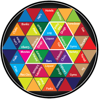
The Crime Risk Kaleidoscope
The spatial dynamics of crime are not the same in different settings, even for the same type of crime. Think about it through the analogy of a kaleidoscope, which represents a particular jurisdiction; The shards of glass represent crime attractors, or features of the landscape, such as bars, fast food restaurants, or grocery stores. Moving from jurisdiction to jurisdiction represents a turn in the kaleidoscope. With each turn, the shards of glass come together in different ways, creating unique spatial and situational contexts that have implications for behavior at those places. RTM is identifies these unique behavior settings for crime in any jurisdiction. Read More
|
|