Risk Terrain Modeling | Official Site
  • Home
  • About
    • RTM Intro
    • Español
    • Data Needs
  • Benefits
  • Getting Started
  • Press and Media
    • Exemplar Award >
      • 2017 Winners
  • Resources
    • Glossary
    • Software
    • Place Features (starter list)
    • Research Evidence
    • In The Classroom
    • Instructor Course Materials
    • RTM Google Group
    • RutgersCPS.org
  • Topics
    • Maps & Tables
    • Risk Narratives
    • Risk Reduction
    • Multi-Method Integration
    • Risk-Based Policing
    • OpSS & ACTION
  • Blog
  • Contact

The RTM Blog

Create and Deploy Actionable Intel

10/26/2018

 
ANALYZE:
The Rutgers RTMDx software, funded by the National Institute of Justice (NIJ), makes Risk Terrain Modeling (RTM) user friendly with its step-by-step wizard-like interface.

Geocode your own data or create new datasets to analyze with the built-in tools. Explore tables and maps in real-time within RTMDx, or download and view them in a GIS (optional). Many analysts open risk terrain maps directly in Google Earth on their computer or mobile device.


DEPLOY & ACT
Share dynamic maps and intel on-the-go.

MAPS: Analysts and commanders deploy risk terrain maps directly to the field via KML files that open in the (free) Google Earth app installed on officers' mobile phones (no need for expensive proprietary mobile apps!). With GPS, officers know exactly where they are in relation to risky places, and where they need to patrol next.

RTMDx autogenerates "all risk", "above average risk", "highest-risk" and "priority places" maps for analysts or commanders to choose from that best meet their operational needs and crime prevention goals. 

CHARTS: RTMDx lists crime attractors at risky places in easy-to read autogenerated charts. These charts add transparency to place-based deployments. Risk scores let you compare and weight crime attractors to prioritize crime prevention efforts.

ACTION:
Analysts and commanders add context to RTM results with their professional experiences and judgement. They decide how best to respond to mitigate risk and prevent crime at the riskiest places. 

At roll-call or via MDTs, SMS, email, BOLO/flyers or dispatcher instructions (PDs decide what works best for them), commanders give orders on what crime attractors to focus on during directed patrols at risky places, and what other actions to take upon arrival.
Deploy maps and intel directly to the field via KML files that open in Google Earth.
Picture
Manage projects; setup and run multiple analyses within each project.
Picture
The RTM Program is all-inclusive, with software, training and technical support included (it costs $5,000/year or less - no additional fees, ever). You always have access to the current best-practices and evidence-based updates. A free option is also available for agencies and individuals.
Picture
Create temporal heat maps to be at the right places at the right times.
Picture
Risk-based policing with RTM follows 3 basic steps: Assess spatial risks, deploy resources to high risk places, and collect data to check for success, then repeat. Use this worksheet as a guide.​
Picture
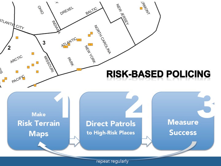
From the book Risk-Based Policing: Evidence-Based Crime Prevention with Big Data and Spatial Analytics (2018 University of California Press)

    Archives

    February 2023
    January 2023
    November 2021
    April 2021
    April 2020
    March 2020
    October 2018
    May 2018
    April 2018
    February 2018
    January 2018
    December 2017
    July 2017
    March 2017
    December 2016
    February 2016
    January 2016
    October 2015

    Categories

    All

    RSS Feed

riskterrainmodeling.com is maintained by the Rutgers Center on Public Security (RCPS). It is the official website of Risk Terrain Modeling (RTM) research and resources, based out of Rutgers, The State University of New Jersey.
  • Home
  • About
    • RTM Intro
    • Español
    • Data Needs
  • Benefits
  • Getting Started
  • Press and Media
    • Exemplar Award >
      • 2017 Winners
  • Resources
    • Glossary
    • Software
    • Place Features (starter list)
    • Research Evidence
    • In The Classroom
    • Instructor Course Materials
    • RTM Google Group
    • RutgersCPS.org
  • Topics
    • Maps & Tables
    • Risk Narratives
    • Risk Reduction
    • Multi-Method Integration
    • Risk-Based Policing
    • OpSS & ACTION
  • Blog
  • Contact