Risk Terrain Modeling | Official Site
  • Home
  • About
    • RTM Intro
    • Español
    • Data Needs
  • Benefits
  • Getting Started
  • Press and Media
    • Exemplar Award >
      • 2017 Winners
  • Resources
    • Glossary
    • Software
    • Place Features (starter list)
    • Research Evidence
    • In The Classroom
    • Instructor Course Materials
    • RTM Google Group
    • RutgersCPS.org
  • Topics
    • Maps & Tables
    • Risk Narratives
    • Risk Reduction
    • Multi-Method Integration
    • Risk-Based Policing
    • OpSS & ACTION
  • Blog
  • Contact

The RTM Blog

Incorporating Time into RTM

12/13/2016

 
Picture
Picture
While it's true that vulnerability to crime varies across space, it is also true that the same places can have varying risk levels depending on the time of day, week or year, despite the stationary nature of a landscape’s physical features. This is because spatial influences* of environmental features are dynamic and can change. For instance, the spatial influence of a bar at 10pm on a Friday is different than its spatial influence at 10am on a Tuesday.
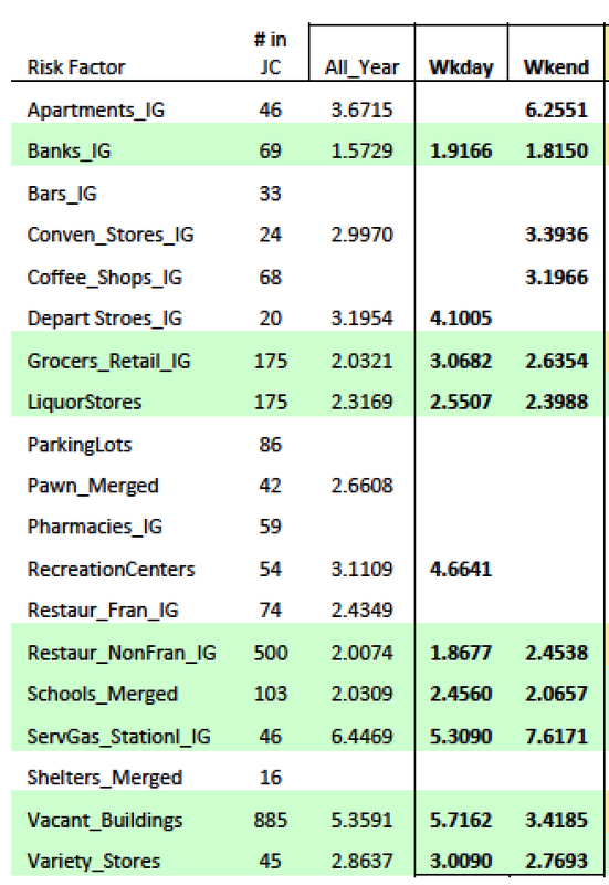
Grubesic and Mack (2008) argued that we cannot treat space and time as independent entities, but, rather, as interdependent ones that interact to create situational risks. The interactions among people and their geographies are deeply fluid in the sense that no feature retains its “social relevancy” permanently (Kinney, 2010, p. 485). Places can be “fantastically dynamic” (Jacobs, 1961/1992; p. 14). Basically, places can have different risks at different times because a criminogenic feature of the landscape can have varying spatial influences depending on its social relevancy at different times and under particular circumstances (e.g. Gaziarifoglu, Kennedy, & Caplan, 2012; Irvin-Erickson, 2014; Yerxa, 2013).

The RTM approach allows not only an assessment of risk factors at certain places, but an ability to judge their effects at different times. To do this with the RTMDx Utility, simply prepare your data by first (1)  isolating crime incidents (i.e. the events you wish to study) that occurred within the time period(s) of interest to you. Then (2) produce risk terrain models for each of the temporally different datasets. For example: create three shapefiles of robberies that occurred between 7pm-3am, 3am-11am, or 11am-7pm, respectively. Then, use these three datasets to run three different risk terrain models. Something similar can be done to study risky places for crimes occurring on the weekend vs. weekdays; daytime vs. nighttime hours; school year vs. summer months; sporting (home) game days vs. (away) game days; etc.
As shown by the sample map and table, to the right, spatial risks may cluster differently across police shifts. Environmental risk factors (and related event contexts*) can also be unique to the week days and weekend days.
Picture
A review of temporal heat maps, such as the one to the left, can inform the production of temporally constrained risk terrain models that isolate the risk factors attracting criminal behavior at peak days or time periods. (Learn how to create heat maps in Microsoft Excel, here). For instance, risk terrain models can be produced for the crime-dense periods of “Monday thru Thursday, from 6-10pm” or “Friday thru Sunday, 5pm to midnight.” This spatial-temporal intelligence fuels stakeholder discussions about the event contexts of crimes nearby to key risk factors to make connections that advance the risk narrative*.

Studying spatial-temporal crime risks with RTM is technically straightforward. Be sure that the time periods you divide your data into are meaningful and considerate of how the information communicated by the risk terrain models and maps will be used for decision-making.

* Glossary (see the full RTM glossary, here)
  • Spatial Influence - The way in which features of an environment affect behaviors at or around the features themselves; The measurable link between features of a landscape and their impacts on people and the ways in which they use space; The articulation of perceptual cues observed about features and gleaned from personal opinions, experiences, and empirical knowledge about similar features or characteristics thereof under other similar circumstances.
  • Event Context - A situational-based understanding of crime incidents that looks at behavioral outcomes as less deterministic and more a function of a dynamic interaction among people that occurs at places.
  • Risk Narrative -- A spoken or written account of connected events. It is a story, so to speak, about how events, such as crimes, relate to other phenomena in their environments.

For references, see Risk Terrain Modeling: Crime Prediction and Risk Reduction (2016; UCPress), by Caplan & Kennedy.
​

Comments are closed.

    Archives

    February 2023
    January 2023
    November 2021
    April 2021
    April 2020
    March 2020
    October 2018
    May 2018
    April 2018
    February 2018
    January 2018
    December 2017
    July 2017
    March 2017
    December 2016
    February 2016
    January 2016
    October 2015

    Categories

    All

    RSS Feed

riskterrainmodeling.com is maintained by the Rutgers Center on Public Security (RCPS). It is the official website of Risk Terrain Modeling (RTM) research and resources, based out of Rutgers, The State University of New Jersey.
  • Home
  • About
    • RTM Intro
    • Español
    • Data Needs
  • Benefits
  • Getting Started
  • Press and Media
    • Exemplar Award >
      • 2017 Winners
  • Resources
    • Glossary
    • Software
    • Place Features (starter list)
    • Research Evidence
    • In The Classroom
    • Instructor Course Materials
    • RTM Google Group
    • RutgersCPS.org
  • Topics
    • Maps & Tables
    • Risk Narratives
    • Risk Reduction
    • Multi-Method Integration
    • Risk-Based Policing
    • OpSS & ACTION
  • Blog
  • Contact